Main menu
Most functions of the application are accessible right from the navigation panel, but you can also tune bGeo according to your personal needs.


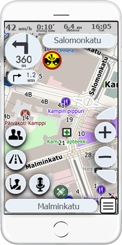
Indication of your current speed. The speed is determined via GPS.
bGeo allows the user to set a speed limit, and when it is overcome the system will give a sound alarm. This will help to meet speed limit requirements.
At the top of the display there is the name of the street after the maneuver, at the bottom - the name of the street along which you move at the moment.
The arrow points in the direction of the next maneuver along the route, next to the arrow there is a distance left before the maneuver. Also the same information is displayed below for the next maneuver, so that the driver can plan the lane change ahead.
Apart from visual indication all maneuvers are voiced in advance. You can set the distance before the maneuver when it should be announced.
By adding other users to your friend list you will be able:
bGeo has a lot of settings that you can use while choosing your route. You can choose between driving or pedestrian routes, set intermediate destination points along the way, drive round toll roads and much more. The route will be set up immediately and will meet user specified options.
One of the unique features of the application is a possibility to exchange information about road conditions in real time. On the map you can see many pictograms set by the users which will inform you about various incidents on the road. In just a couple of touches you can set an event pictogram on the map and let other users know about traffic accident, bad road conditions, speed cameras, etc.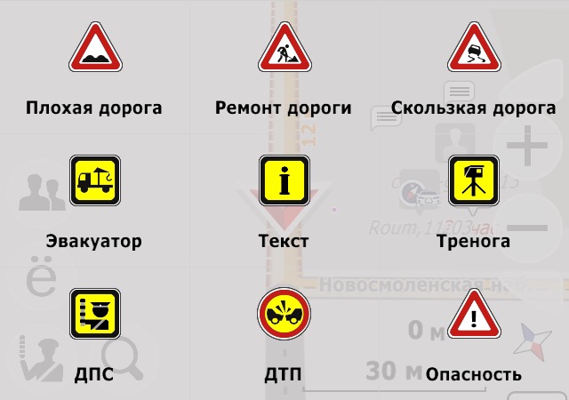
Calculated time of arrival, distance and time left to destination point are displayed at the top.
bGeo will inform you about speed limit on the current road section, about speed camera ahead, dangerous road section etc. This will help to follow driving regulations and save money on traffic tickets.
Visual hints are supported by voice warnings so that you can fully pay attention to the road.
Something that you will not find in other navigators. In bGeo you can use a voice chat. Choose from multiple thematic channels and communicate with other users. You won’t get bored behind the wheel.
Most functions of the application are accessible right from the navigation panel, but you can also tune bGeo according to your personal needs.
Download bGEO from the application store available on your device. In seconds after program start you can see your location on the map and configure the route. This can be done by clicking on the destination point right on the map or via address or POI search.
Once you downloaded map files to your device bGEO will use them without connecting to the Internet. If there is Internet connection the program will automatically download from the server the latest navigation data.
In this operation mode bGEO shows a 3D map using not only GPS data, but also compass to determine your location.
If you turn the program map turns with you displaying the same objects as you see them in reality. At the top of the display there will be information about all POI that are before you.
At this point you can click on any object and get detailed information.
the most modern digital cartographic technology based on years of experience and successful realisations of terrain and marine navigation solutionson.
2016 © All Rights Reserved. Privacy Policy | Terms of Service